
The route is mainly on good forest tracks and footpaths, apart from a mile of beach at Tayinloan and half a mile of rocky shore south of Carradale. There is a steep descent to Ifferdale which may be muddy and slippy depending on the weather. Various works are in progress so we will produce the gpx nearer the time.
Regulars will be glad to know that the second checkpoint and changeover will be back to the Corrylach Farm location on Lussa Loch, where there is access from the south for relay teams (not for spectators).
Stage 1 Tayinloan to Carradale
15 miles, 560m climb
Water at Deucheran 6 miles
Water at B842 Grianan Car Park 11 miles


From Tayinloan Village Hall, (what3words full.grafted.skewed) turn left, follow the way marked path through the houses, then towards the beach and back along the edge of a field to the A83. Take care when crossing.
Head up a broad forestry track. If you do stop for a minute and look back, you will be rewarded with views across the seascape, to Cara and Gigha in the foreground and beyond to Islay and Jura.
After the flat open section at the 300m level, there is a water station. The forest road loses some height, passing a junction on the right to cross Drochaid Bum before climbing again towards Deucheran Hill and its wind farm.

Stay on the main road through the wind farm – there are numerous turnoffs to the towers. The forest road descends into the glen of Carradale Water, with a stretch of tarmac surface on the steepest part of the descent. A few hundred metres after this, continue straight ahead at a junction.
It feels wrong to be going north but eventually the road passes Auchenbreck Farm, crosses the stream and leads up to a four way intersection where you finally turn right and south, a popular place for going wrong!

The descent down the Glen to join the B842 near Brackley Cemetery is extremely pretty. Head south down the B842 then turn left at the Grianan car park and water-station. Take the middle track with the Kintyre Way marker leading east from here. Follow the narrow track through mixed forest, steeply after a while, to a junction on the left. Continue along the forest road still climbing. Emerging from the trees, it rises to a crest with grand views over the Kilbrannan Sound.
Follow our signs (not the Kintyre Way signs) on the forest track bringing you to a car park after which it’s only 50 yards to the B879. Cross with care and turn right along the footpath to the checkpoint at the village hall (what3words overture.linen.fatigued) (about 1 mile). Toilets and refreshments are available.

Section 2. Carradale to Lussa Loch
13 miles, 720m climb
Water at Ifferdale
From the village hall, run along the minor road for 100 metres then follow the race day arrows until rejoining the Kintyre Way at a Kintyre Way information board. Take the path signposted for Carradale West Services. This takes you round to the B842. Over the bridge, turn left again towards Waterfoot. A Kintyre Way information board is at the junction warning about Carradale Bay tide times as part of the route ahead is impassable at high tide. (Should this be the case on race day a diversion along the road will be signed.)

Follow the footpath to the shingle beach and tidal grassland. Carry on along the rocky shore (this is a bit of a scramble) that leads to a small cove. Cross the burn, then turn inland. Go up to the edge of a grassy bank. Keep to the left as far as a gully, then turn right and head up the field to a stile over the fence, taking care as you are joining the B842.

Cross the B842 and follow it downhill for 400 yards, then turn right at a white gatehouse on to a track leading towards Torrisdale Castle (home of sponsors Kintyre Gin). Follow waymarkers through the castle grounds towards Lephincorrach. Go through the farm and past the distillery, turn right at the intersection, then go through a small gate. There is an excellent cafe and spectator point at the distillery. Climbing steadily round a right-hand bend, pass a Kintyre Way distance marker indicating that you’ve reached the halfway mark at 50 miles.
Bear left just short of the forest and take the track below the woods at a Y-junction. Then, follow the path between the stream and the woods beside a weir. A sign says, ‘Thank you for walking the Gintyre Way’.
Within 100 yards, cross a footbridge and follow the path as it zigzags across the moorland and up to the forest road network. Take the sharp left turn at another Y junction then watch for the right turn off the forest road onto the steep, narrow descent to cross the Guesdale Water.
Cross a small burn. Go through a gate and cross the field ahead to exit it by another gate. Turn right to continue on the Kintyre Way. At the junction with the Ifferdale Farm road, turn right passing Ifferdale Cottage and the sheepfold into the glen of Ifferdale Burn.
Water station at the junction.
Follow the waymarked forest road south west through more wind farms, swinging east. (Don’t take the left turn down the east side of the loch, used in 2023, where there is a small grove of trees ‘Hughie’s Wood’, planted in memory of forester Hugh Macmillan (1927–1990), who was brought up in the cottage.) Instead, continue east and finally south to cross the Strathduie Water and head down the west side of Lussa Loch to the checkpoint at Corrylach.
Note: relay changeover cars must approach from the south as the gate to the north is padlocked. Although accessible by car as far as the farm, it is not safe for spectators as this is a single track road which the runners will be using.
Section 3. Lussa Loch to Campbeltown
6 miles, 130m climb
From there continue south to the junction a little south of Gobagrennan
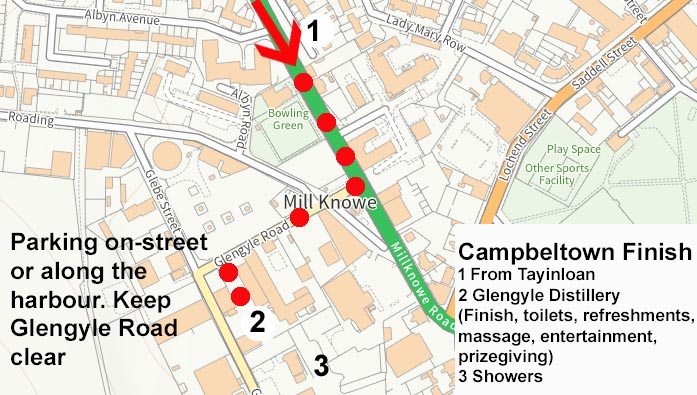
Follow the minor road heading south toward Campbeltown. Look out for views to the south-west over to Machrihanish. Finally join the A83 on the outskirts of Campbeltown where a short run along the pavement will bring you to the finish at Glengyle Distillery (what3words used.tumblers.fumes).


Well done!